File:NorthAmerica1762-83.png
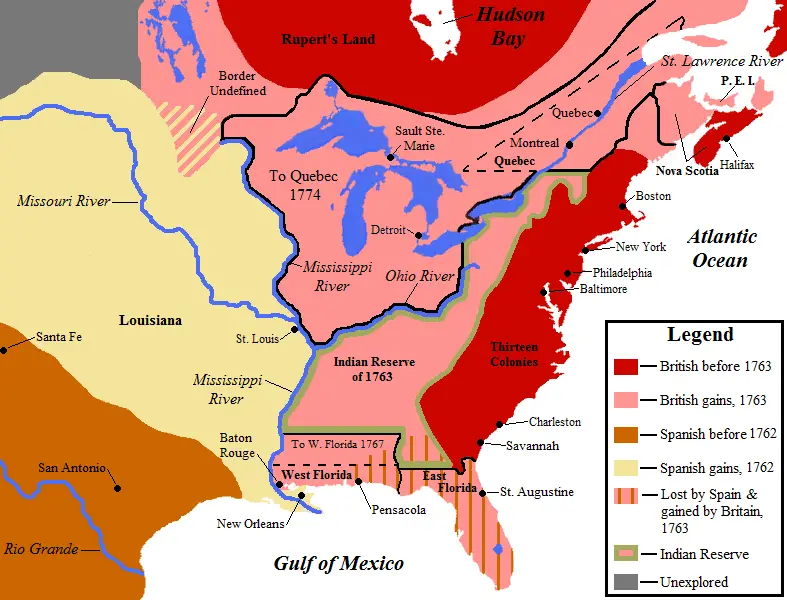
English: Map showing territorial gains of Britain and Spain following the French and Indian War. Also shown are boundary changes within the territory the British had acquired between 1763 to 1783.
Territorial lands held by the British before 1763 is shown in red, land gained by Britain in 1763 is shown in pink.
The lands ceded to the Kingdom of Spain in secret during 1762 are in light yellow. , and also set-off are the lands Britain promised to close to white settlement - a causus belli to many Americans leading to support for the American Revolution.
28 September 2008 Source Own work ( Base map used is found here, uploaded by Roke ) Author Jon Platek
File history
Click on a date/time to view the file as it appeared at that time.
| Date/Time | Thumbnail | Dimensions | User | Comment | |
|---|---|---|---|---|---|
| current | 03:33, 14 May 2019 | | 787 × 600 (90 KB) | Admin (talk | contribs) | English: Map showing territorial gains of Britain and Spain following the French and Indian War. Also shown are boundary changes within the territory the British had acquired between 1763 to 1783. Territorial lands held by the British before 1763 is s... |
- You cannot overwrite this file.
File usage
The following page links to this file: